
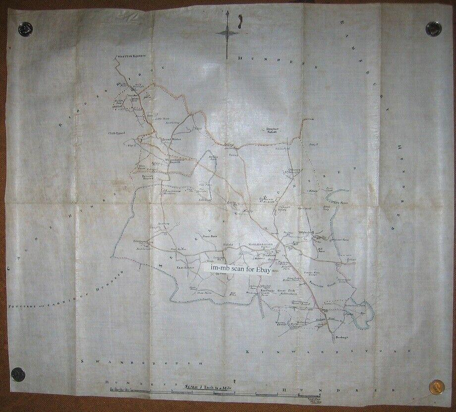

A VICTORIAN hand drawn map of the Marlborough area has cropped up for sale on internet auction marketplace Ebay.
Signed by the artist F.J.N Glass in February 1862, it’s been posted by a rare book dealer in Norfolk.
It features the areas of Beckhampton, East Kennett, Draycot Foliat, Fifield and Mildenhall as well as Savernake and Burbage.
The map is on paper which has been folded and is around 52cm wide and 46cm long, with an approximate scale on one inch to one mile.
It is all hand drawn in black ink, with some pink, yellow and blue watercolour tinting.
The seller, Malcolm Books of Thetford in Norfolk describes it as having been drawn on 'some sort of strong tracing paper, which could also be a thin material, possibly silk with the map drawn on the shiny side'.
The old spelling of Marlborough - Marleborough - is written in ink on the back. Its condition is described as fair to good, mostly very good, with a minor ink stain at the top.
It would appear that the map had been badly folded at some point, with fold creases remaining from when it was folded down to about 9cm x 23cm.
The Old Bath Road from London to Bath, now the A4, is at the centre of the map. It shows the nearby area for about six miles around, with names of some of the villages, farms, rivers etc using Victorian spellings.
Top left is Wotton Bassett, down past Cliffe Pypard, Berwick Bassett, Bockhampton to East Kennet. At its centre is Draycot Foliat, and Fifield.
“This looks to be a unique early Victorian hand drawn map.” said the seller. “It is suitable for a local museum or library, but sadly they rarely buy from the net.” The auction ends on Wednesday and bids start at £100.


Comments: Our rules
We want our comments to be a lively and valuable part of our community - a place where readers can debate and engage with the most important local issues. The ability to comment on our stories is a privilege, not a right, however, and that privilege may be withdrawn if it is abused or misused.
Please report any comments that break our rules.
Read the rules here